
Monitors and monitoring locations
What monitors do we use? How do we process our data? How do we choose sites for our monitors? And where are our current sites?
We use sensor nodes from the Berkeley Environmental Air-quality and CO₂ Network (BEACO₂N) project at the University of California, Berkeley. The nodes require power (110V) and can be equipped to use wireless internet or cellular networks. We mount them either on permanent rooftop railings or on freestanding tripods at our sites. By deploying these sensors, we also hope to advance the science of lower-cost air quality monitoring and data interpretation.
What monitors do we use?

This diagram shows the various parts of each monitor and what they measure. Individual sensors are: Bosch Sensortec BME280 (temperature and humidity); Alphasense CO-B4, NO-B4, NO2-B43F, OX-B431 (carbon monoxide, nitrogen oxides, and ozone); Vaisala CARBOCAP Carbon Dioxide Probe GMP343 (carbon dioxide); and Plantower PMS5003 (particulate matter).
Calibrating the monitors and correcting data
External factors like temperature and humidity affect each sensor differently and can influence both the accuracy and precision of the data we collect. We want to ensure that our monitors react the same way to the same concentrations of pollutants, and that each monitor's reading is accurate to what’s present in the air. In order to do this, we calibrate the sensors and correct the data that they collect.
How do we choose sites for our monitors?
Our site selection process has been multifaceted and collaborative. We began by consulting Racial and Environmental Justice Committee and the City of Providence’s Climate Justice Plan and statements from community advocates. These resources in combination with conversations with community partners helped us identify potential priority monitoring areas and population characteristics. We considered questions such as: “What knowledge, from both local and scientific communities, already exists about Providence air quality? Who is bearing the brunt of pollution’s burden? What is currently being done to address these issues?”
We then built a Geographic Information Systems (GIS) model out of the priorities that emerged, focusing on specific vulnerable populations like frontline communities, people with respiratory diseases, children, and the elderly. The result was an Air Quality Vulnerability Index (AQVI) that represents Providence neighborhoods by estimated vulnerability to air pollution. Regions with increased vulnerability to air pollution are designated as priority areas. We have used the AQVI as a tool to guide and evaluate the monitoring site selection process.

Schools, libraries, and community and recreation centers in priority areas are among the types of locations we look for when siting a sensor. These are public-serving institutions where people gather, learn, and play. Eventually, we hope that we can tap into the communication channels that these spaces have cultivated in order to foster conversations about air quality and community health.
Prepared with ideas for potential sites, we meet with community-based organizations and city offices for guidance and feedback, co-designing our monitoring network and connecting with possible site hosts. When we visit sites, we look for buildings one to two stories tall with a flat roof and access to a power outlet. We then continue this process—refining our list of potential sites, returning to community partners, and connecting with more people.
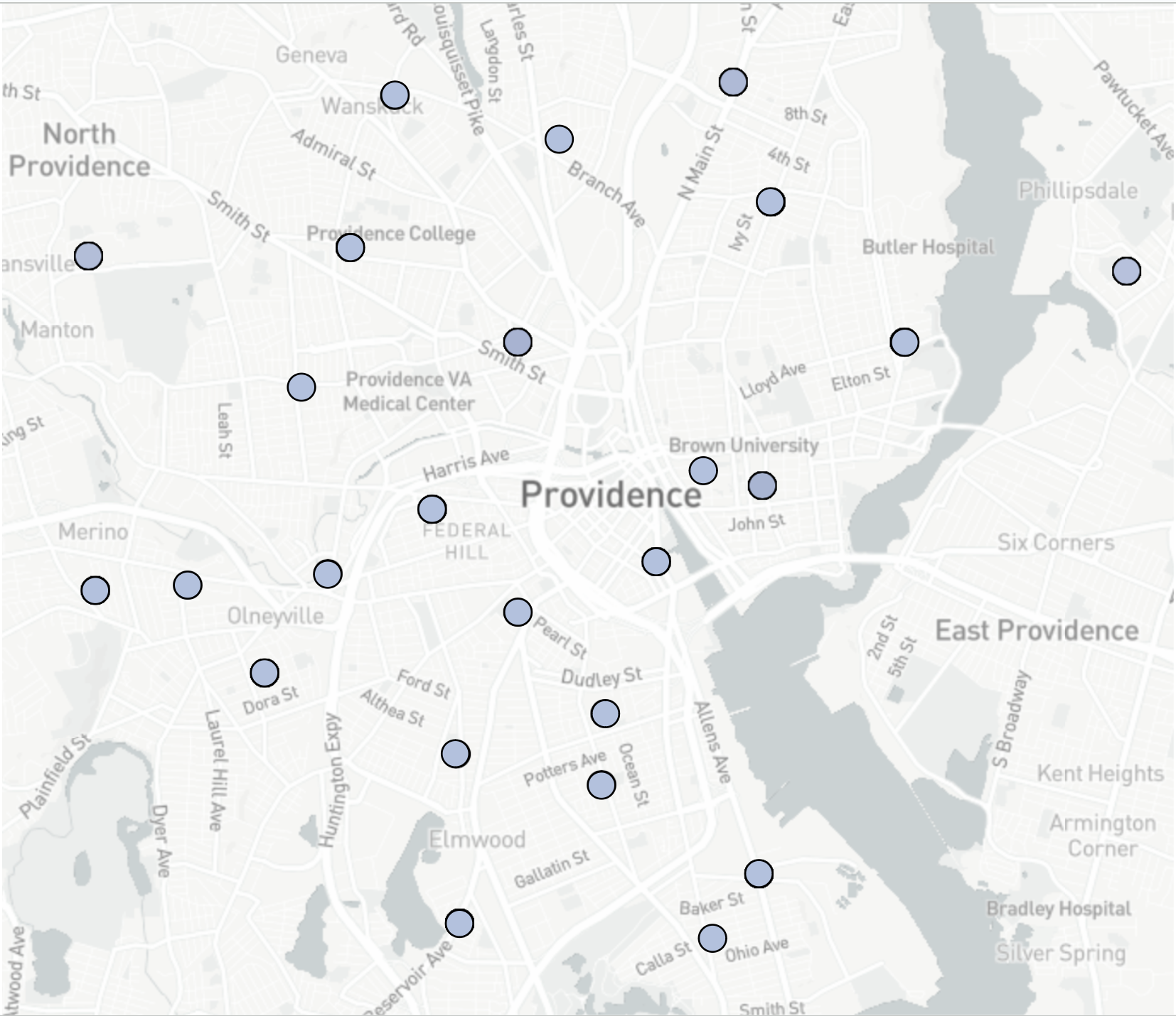
Our sites
We have set up monitors at 25 sites. Their locations are:
Myron J. Francis School
60 Bourne Ave, installed 7/11/22.
This sensor is co-located with DEM monitors.
West End Community Center
109 Bucklin St, installed 9/2/22.
Providence Public Works Department
700 Allens Ave, installed 8/16/22.
Providence Housing Authority
40 Laurel Hill Ave, installed 8/16/22.
Warren Alpert Medical School
222 Richmond St, installed 7/28/22.
Smith Hill Library
31 Candace St, installed 8/25/22.
South Providence Library
441 Prairie Ave, installed 8/25/22.
Rochambeau Library
708 Hope St, installed 8/25/22.
Zuccolo Recreation Center
18 Gesler St, installed 10/4/22.
Community College of RI Liston Campus
1 Hilton St, installed 10/27/22.
This sensor is co-located with DEM monitors.
Main Street Martial Arts
1282 N Main St, installed 11/11/22.
Reservoir Ave Elementary
56 Reservoir Ave, installed 11/17/22.
E-cubed Academy Senior High School
812 Branch Ave, installed 11/17/22.
United Way of RI
50 Valley St, installed 11/19/22.
Silver Lake Residence
Priscilla Ave, installed 12/1/22.
Carnevale Elementary
50 Springfield St, installed 12/6/22.
Rock Spot Climbing Gym
42 Rice St, installed 12/15/22.
Brown-Fox Point Early Childhood Education Center
150 Hope St, installed 2/10/23.
Blackstone Residence
Grotto Ave, installed 3/6/23.
Rhode Island College
Ducey Media Center, installed 3/16/23.
Providence College
Hickey Hall, installed 3/16/23.
Child & Family Services
1268 Eddy St, installed 5/25/23.
Mt. Pleasant Hardware
249 Academy Ave, installed 9/1/23.
John D. Rockefeller Library
10 Prospect St, installed 12/4/23.
Providence Emergency Management Agency
591 Charles St, installed 8/23/24.